
Image Fusion and Spectral Transformation
Image fusion is a concept of combining multiple images into composite products, through which more information than that of individual input images can be revealed.
As an example of image fusion, pan-sharpening describes a process of transforming a set of coarse (low) spatial resolution multispectral (colour) images to fine (high) spatial resolution colour images, by fusing a co-georegistered fine spatial resolution panchromatic (black/white) image. Typically, three low-resolution visible bands - blue, green and red - are used as main inputs in the process to produce a high-resolution natural (true) colour image. Figure 1 illustrates this: the middle image is a natural colour image with a spatial resolution of 2.4 m (resampled 400%), and the left image a panchromatic image with a spatial resolution of 0.6 m; by combining these inputs, a high-resolution colour image is produced. In the fused output, spectral signatures of the input colour image and spatial features of the input pan image, as the best attributes of both inputs, are (almost) retained. The spectrally and spatially enhanced image is often visually appealing, starting to compete with high-resolution aerial photographs.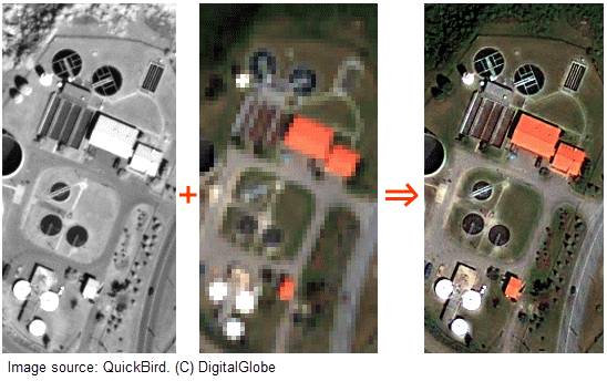 |
|
Figure 1: Image pan-sharpening with QuickBird images. The left and middle input images are obtained from DigitalGlobe, and the right-hand image is the fused result. All images are subject to the same histogram stretching. |
The past few decades have seen quite a few image fusion and pan-sharpening methods in the public domain, including those based on multi-resolution wavelet transforms, PCA (Principal Component Analysis) transforms, and IHS (Intensity-Hue-Saturation) transforms. These methods, however, largely disregard important spectral characteristics of specific satellite sensors, therefore no consistent, colour-preserving results can be achieved. In other words, a simple data-driven approach without referring to spectral evidence can hardly produce satisfactory outcomes. This becomes more apparent when the recent generation of high- and medium-resolution satellite images is available, where there are marked spectral disparities between colour bands and the panchromatic band.
For more information on spectral features and curves of a few recent satellite sensors, please refer to websites of major image providers:
https://sentinel.esa.int/web/sentinel/missions/sentinel-2 (Sentinel-2)
http://landsat.usgs.gov/ (Landsat 8)
www.digitalglobe.com (WorldView-3, WorldView-2, QuickBird)
http://www.intelligence-airbusds.com/ (Pléiades, SPOT series)
Korea Aerospace Research Institute (KOMPSAT-2)
Taiwan National Space Organization (FORMOSAT-2)
Japanese Advanced Land Observing Satellite (ALOS, or "Daichi")
|
"Our land is so real and
abundantly beautiful, and the imagery of
our land is so captivating. As human being
each of us has the potential to be a great
scientist and/or artist,
and let's explore the imagery of our land
together..." |